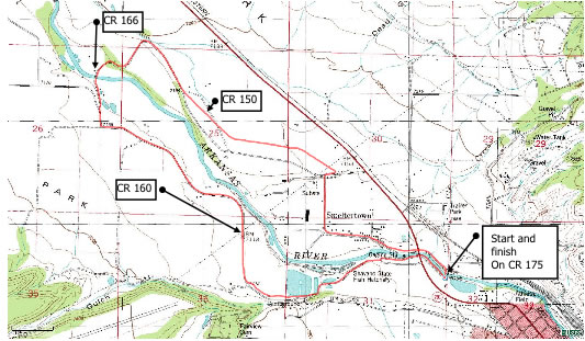
This is a pleasant, relatively flat, smooth & continuous loop above Salida. The loop is mainly on low traffic paved county roads. There are no road crossings or intersections to deal with, so it lends itself to uninterrupted running. There is only 550’ of climbing, with the same amount of descent.
The loop can be combined with other loops, and has a few other routes/loops that split off of it. The loop takes you past lakes, right next to the Arkansas River, through ranchlands, past the
historic Smeltertown smokestack, and offers great mountain views. Start the loop at the Sand Lake State wildlife area parking lot. This is located just NE of downtown
Salida by turning off Highway 291 onto CR 175. (Across the highway from the Hospital). The description/distances below are from the painted pedestrian crosswalk just west of Sand Lake on CR 175, doing the loop clockwise.
Clockwise directions starting from Sand Lake. Head upstream on wide gravel path next to river from CR 175 crosswalk next to the Bridge.
At .55 miles, path parallels road next to fence as paved shoulder for 200 yards before becoming gravel path between road and lakes again. Then parallel road/parking lot on gravel paths keeping Franz lake(s) on your right.
At 1.38 miles, leave gravel path and go between rocks to get on paved CR 160. At 3.01 miles, fork right onto CR 166. CR 166 drops down to cross bridge and becomes gravel. At 3.64 miles, turn right on paved CR 150. At 5.11 miles at the bottom of a little downhill, CR 150 turns sharply to the right (towards Smokestack) and then heads left. At 6.30 miles, turn right on CR 175 and cross bridge back to start.
Jog the half mile gravel path loop around Sand Lake to cool down. Beware of the Goose!